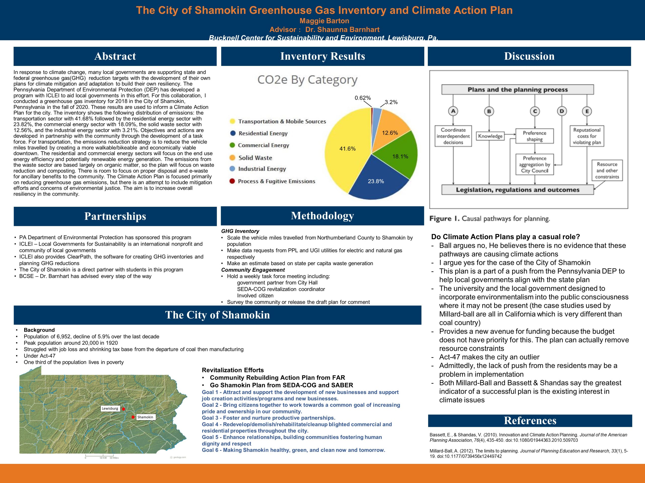
CLIMATE ACTION PLANNING FOR THE CITY OF SHAMOKIN

In response to climate change, many local governments are supporting state and federal greenhouse gas(GHG)  reduction targets with the development of their own plans for climate mitigation and adaptation to build their own resiliency. The Pennsylvania Department of Environmental Protection (DEP) has developed a program with ICLEI to aid local governments in this effort. For this collaboration, I conducted a greenhouse gas inventory for 2018 in the City of Shamokin, Pennsylvania in the fall of 2020. These results are used to inform a Climate Action Plan for the city. The inventory shows the following distribution of emissions: the transportation sector with 41.68% followed by the residential energy sector with 23.82%, the commercial energy sector with 18.09%, the solid waste sector with 12.56%, and the industrial energy sector with 3.21%. Objectives and actions are developed in partnership with the community through the development of a task force. For transportation, the emissions reduction strategy is to reduce the vehicle miles travelled by creating a more walkable/bikeable and economically viable downtown. The residential and commercial energy sectors will focus on the end use energy efficiency and potentially renewable energy generation. The emissions from the waste sector are based largely on organic matter, so the plan will focus on waste reduction and composting. There is room to focus on proper disposal and e-waste for ancillary benefits to the community. The Climate Action Plan is focused primarily on reducing greenhouse gas emissions, but there is an attempt to include mitigation efforts and concerns of environmental justice. The aim is to increase overall resiliency in the community. Continue reading CLIMATE ACTION PLANNING FOR THE CITY OF SHAMOKIN

Homelessness Research and Awareness Project

The Homelessness Research and Awareness Project seeks to address the rising issue of homelessness within Shamokin, PA. This project is being completed at the request of The Faith Alliance for Revitalization, a coalition of nonprofits, businesses, volunteers, and government in the Shamokin area. The goal of the research project is to better understand the problem of homelessness in the area by talking with organization leaders such as those in the church, library, social work, non-profits and government agencies, and the police department. The project will be completed by combining a literature review of how other rural towns have addressed the needs of homeless populations with the perspectives of local agencies. Ultimately, this project will culminate in a proposal to be submitted to the local government to provide resource ideas to support the homeless population and help to alleviate poverty in the area. Continue reading Homelessness Research and Awareness Project

Effect of Nitrates on Algae Bloom Formation

One of the largest threats to aquatic ecosystems are harmful algae blooms (HABs) which are caused by excess levels of nutrients such as phosphorus and nitrogen. Agricultural runoff is a relevant issue in North East Pennsylvania (NEPA) and a leading source of phosphorus and nitrogen into waterbodies. Excess of nitrates in soils that are not taken up by plants can seep into private drinking water wells. The overabundance of nitrates causes adverse human health effects as well as environmental havoc. Nitrates in drinking water can cause severe health problems for infants and the elderly, as well as minor to moderate problems for younger healthy people. According to the EPA, the lowest unnatural concentration of nitrates in drinking water is 1mg/L, which indicates an anthropogenic presence, and the maximum contaminant level (MCL) is 10mg/L, at which adverse human health effects are known to occur. In order to determine the relationship between algae growth and the presence of nitrates, Anabaena cyanobacteria was exposed to contaminant concentrations of 1 mg/L, 5 mg/L, and 10 mg/L based on the EPA standards. The algae content was measured using a spectrometer. The correlation between absorbance and nitrate concentration was analyzed to determine how algae growth varies with nitrate contamination. Preliminary results showed that an overabundance of nitrates such as 10 mg/L causes excess algae growth, it can be assumed that increased algae growth, absorbency values around 0.227, is indicative of higher nitrate concentrations. Therefore, it follows that increased algae populations implies a risk of nitrate contamination in drinking water. Continue reading Effect of Nitrates on Algae Bloom Formation

The Influence of the Transport of PM 2.5 and Ozone on Lancaster County Air Quality

The collateral impact of emissions present in the atmosphere is exacerbated by the increased in ambient air temperatures. Utilizing the Environmental Protection Agency ‘s (EPA) outdoor air quality data from AirNow, we focus on the pollutants ozone and PM2.5 in Lancaster, Pennsylvania. This study is focused on days that recorded daily ozone and PM2.5 Air Quality Index (AQI) values that fell within a range of air quality that is unhealthy for sensitive groups to hazardous quality. Over the past two decades, 2000-2020, the days that reached AQI values within the range of focus decreased.

The most populated region of the United States is the Northeast Corridor. A megalopolis with a high concentrations of human activity can cause environmental health problems. Historically, the New York-Newark, Washington-Baltimore-Arlington, and Philadelphia-Reading-Camden regions make the American Lung Associations’ State of the Air Report’s top 25 Most Polluted Cities in the country for ozone. In the most recent State of the Air report, Lancaster, Pa was ranked 27 of 203 metropolitan areas for annual particle pollution. We generated Hybrid Single-Particle Lagrangian Integrated Trajectory (HYSPLIT) backward trajectory models starting at Lancaster, Pa for each day with ozone exceedances between 2010-2020. That decade recorded 78 days with high ozone values. Of those 78 days, 44% of days have models that show air particles from metropolitan areas along the Northeast Corridor present in Lancaster air. Continue reading The Influence of the Transport of PM 2.5 and Ozone on Lancaster County Air Quality

Nature’s Unifying Patterns: Sustainable Biomimicry

In fall 2020, I added a sustainability component to my elective course, BMEG 431: Biomimetic Materials. The Biomimicry Institute (biomimicry.org) defines biomimicry as “the practice of looking to nature for inspiration to solve design problems in a regenerative way.” The implication is that it is not enough to look to nature for design solutions to specific problems, but that rather you should apply “Nature’s Unifying Patterns” to ensure that the designs are implemented in a sustainable way that is compatible with our natural world. According to this site (https://toolbox.biomimicry.org/core-concepts/natures-unifying-patterns/), Nature:
• uses only the energy it needs and relies on freely available energy,
• recycles all materials,
• is resilient to disturbances,
• tends to optimize rather than maximize,
• provides mutual benefits,
• runs on information,
• uses chemistry and materials that are safe for living beings,
• builds using abundant resources, incorporating rare resources only sparingly,
• is locally attuned and responsive, and
• uses shape to determine functionality.
To introduce these patterns, we took a field trip to a Bucknell Center for Sustainability & the Environment (BCSE) field site to find examples of these patterns in both the natural environment and in the choices made in designing the site, such as how to collect and distribute water. Throughout the rest of the course, we evaluated each new biomimicry example we studied against these criteria. Finally, the class did a service project with the Bucknell Farm. After visiting the farm, the students brainstormed projects they could do to promote Nature’s Unifying Patterns at the farm. They came up with two projects compatible with the Farm’s goals and Nature’s Unifying Patterns: (1) a native plant pollinator garden, and (2) water swales for a future orchard to naturally enhance irrigation of the trees. A clickable map of both sites was also created by the remote students. Both projects were completed by the end of the semester. Continue reading Nature’s Unifying Patterns: Sustainable Biomimicry

Montgomery County Greenhouse Gas Inventory and Climate Action Plan

In response to climate change and global warming altering the environment, local governments are responding by seeking to create plans to combat the changes. This independent study with the Bucknell Center for Sustainability and the Environment involves working with Montgomery County Consortium of Communities (MCCC) to create their Greenhouse Gas Inventory and an accompanying Local Climate Action Plan (LCAP). As part of a state wide cohort, the Department of Environmental Protection and ICLEI-Local Governments for Sustainability are helping to support local governments in developing LCAPs to assist Pennsylvania in achieving its climate goals. Using data from the Delaware Valley Regional Planning Commission, a MCCC greenhouse gas inventory was created and documented on ClearPath. This inventory was then used to inform a LCAP, a process that also included creating a task force within the community to identify hazards, vulnerabilities, projection goals, reduction goals, and strategies. The results exemplified that the greatest emissions of carbon were from commercial energy, transportation and mobile sources, and residential energy. Furthermore, the greatest hazards of the communities were drought and rising temperatures which would impact citizens, infrastructure, and other things. Therefore, MCCC LCAP created a task force of multiple stakeholders to reduce emissions. This LCAP creates a unifying proposal for the coalition of communities to adapt to similar goals and strategies to mitigate climate change. Acknowledging the importance for local governments to lead their own change, MCCC hopes to address sustainability dilemmas by halting emissions and extreme weather impacting local PA communities. Continue reading Montgomery County Greenhouse Gas Inventory and Climate Action Plan

The Importance of Ventilation in COVID-19 Transmission

The COVID-19 virus has been a part of everyone’s lives for over a year but there are still many misconceptions about how the virus is transmitted. In this poster we will show educational materials we created that aim to clarify the main transmission method of the virus, which is through respiratory droplets and aerosols. Respiratory droplets (diameter of 10-100 microns) or aerosols (diameter less than 10 microns) come from an infected person’s mouth or nose when they breathe, talk, sneeze, or cough. In a poorly ventilated room, these particles can linger in the air and infect others. In addition to wearing masks properly, ventilation can reduce COVID-19 transmission. Ventilation brings in outdoor air to dilute air particles related to COVID-19, and also other air pollutants and pathogens. Measuring CO2 is one way to estimate how often air is being exchanged in a room, with higher CO2 levels could indicate a low level of ventilation. Students in CEEG 443 measured CO2 cocentrations on and around campus. Our measurements show that ventilation can be improved by opening up windows or by using mechanical ventilation. As the pandemic continues, understanding the power of ventilation and its role in virus transmission is more important than ever. Continue reading The Importance of Ventilation in COVID-19 Transmission

CO2 Ventilation On Bucknell’s Campus

Carbon dioxide monitors have been used by Professor Sills’ Sustainable Design course to provide information about CO2 levels in different environments on and off of Bucknell’s campus. Carbon dioxide levels can be representative of ventilation in a given area, but also should be examined with caution because they can be affected by other factors. Measuring ventilation is important because of the way that airborne viruses spread through aerosol particles. This is especially important on Bucknell’s campus as ventilation readings can give an indication on the level of risk for spreading COVID-19. The main findings through measuring the carbon dioxide on campus was that ventilation in campus settings was generally pretty good. This is specifically apparent in classrooms, study spaces, and dining halls. Dorm rooms and residential spaces generally had less ventilation and higher CO2 levels compared to educational spaces on campus. This result broadly explains the importance of letting students have the ability to be in-person for class and other campus activities. This result may also explain that the spread of COVID-19 may happen more often in residential spaces. These results could provide insight to potential policy changes in the coming years. Continue reading CO2 Ventilation On Bucknell’s Campus

Regenerative Agriculture on the Bucknell Farm

The Bucknell Farm is planning on planting an orchard to cultivate various fruit trees. The proposed location of the fruit trees is on a slope. To prevent runoff of rainwater downslope, the Bucknell Farm would like to implement a form of passive irrigation. Passive irrigation uses water from the environment in contrast to active irrigation which takes water from a municipal source. The Bucknell Farm has already constructed two bioswales, which is a passive method of irrigation that slows down rainwater and allows it to seep into the soil instead of running off. Bioswales consist of a swale and berm. A swale is a long shallow trench from which the soil is removed and piled on the downhill side to create the berm. The trees will be planted in the berm to hold the soil in place and utilize the rainwater that gets absorbed. Professor Deborah Sill’s Sustainable Design Course has been working with the farm to measure soil moisture adjacent to the bioswale and in other parts of the farm to evaluate the effectiveness of bioswales in improving soil moisture. Continue reading Regenerative Agriculture on the Bucknell Farm

A New Tick in Town: Distribution and Density of the Invasive Asian Longhorned Tick (Haemaphysalis longicornis) in Pennsylvania

Since the recent introduction of the Asian longhorned tick (Haemaphysalis longicornis Neumann) in the United States, quantitative surveillance information remains lacking. We conducted statewide, active tick surveillance from May to August 2019 and report data on H. longicornis geographical distribution and population density in Pennsylvania. We collected 615 H. longicornis from four counties. Across samples recovering H. longicornis, mean density of H. longicornis was 9.2/100 m2, comparably greater than Ixodes scapularis Say (8.5/100 m2). Density of H. longicornis was also significantly greater in August, largely driven by larvae, and greater in recreational habitat types (12.6/100 m2) and in Bucks County (11.7/100 m2), situated adjacent to the location of the first U.S. discovery of intense infestations. These data are among the first to document H. longicornis from statewide tick surveillance and provide initial measures of population density enabling more quantitative characterizations of distributional patterns. Continue reading A New Tick in Town: Distribution and Density of the Invasive Asian Longhorned Tick (Haemaphysalis longicornis) in Pennsylvania